PRESS RELEASE

SANDWICH, Mass., November 14, 2023 – Horsley Witten Group, a full-service environmental consulting firm providing sustainable and resilient environmental design solutions, has partnered with the Town of Mashpee, the Massachusetts In-Lieu Fee Program, and the Massachusetts Division of Ecological Restoration to restore the former Chop Chaque cranberry bogs to healthy, thriving wetlands similar to what they were prior to conversion to cranberry farming approximately a century ago.

There are two cranberry bogs at Chop Chaque totaling 6.5 acres that are situated on a nearly 12-acre town owned parcel of land adjacent to Santuit Pond. The cranberry bogs have been out of production for approximately four years.

Since cranberry cultivation has become more economically challenging in recent decades for farmers on Cape Cod, many have opted to retire bogs and place the land under conservation easement protection. Municipalities and other conservation entities that acquire the land or the conservation easement for these retired bogs often seek to restore them to something similar to the natural wetlands that existed prior to the conversion to cranberry agriculture and that will better support complex ecosystems and associated habitat. Ancillary benefits, such as improved nutrient management, are also often realized.


“It is a major trend and for good reason – restoring cranberry bogs to their natural state benefits the environment, encourages the return of wildlife and rare species habitats and contributes to the health of our waterways,” said Horsley Witten Group Principal Scientist Neal Price. With no restoration, intervention frequently fails to allow for recovery of wetlands systems with wetland functions and values similar to what would have existed prior to the original establishment of cranberry agriculture.”

The Chop Chaque project is being funded through a $525,000 In-Lieu Fee Program allocation from the Massachusetts Department of Fish & Game.  Horsley Witten Group was responsible for assessment of the Chop Chaque site, developing designs for restoration, which will include removal of the excess sand that had been added periodically over the decades of agriculture, filling artificial ditches, roughening bog services, removing a culvert that connects Santuit Pond to the bogs, and permitting of the project. Final design, construction, and post-project monitoring are still to come. Construction work on the Chop Chaque restoration project is expected to begin during the fall of 2024 and be completed in approximately two to three months.


“We look forward to once again working with Horsley Witten Group on this important ecological restoration project,” said Mashpee Conservation Agent Andrew McManus. “The organization and its team of talented and accomplished environmental scientists have worked with the Town of Mashpee on a wide range of projects including culvert replacement, dam repair and planning, and permitting processes.”

Horsley Witten Group has also managed or participated in other local cranberry bog restoration projects in Mashpee, Falmouth, Marstons Mills, Plymouth, and Yarmouth.


NEWS RELEASE

Planning Industry Veteran to Lead Environmental Consulting Firm:

SANDWICH, Mass., June 20, 2023 – Horsley Witten Group, a full-service environmental consulting firm providing sustainable and resilient design solutions, has announced the appointment of Nathan “Nate” Kelly to the position of president.

Kelly succeeds Richard Claytor, Jr., P.E., who will remain with Horsley Witten Group as senior water resources engineer and will continue to serve on the company’s board of directors. Claytor led the firm for over a decade and is a prominent leader in the stormwater management field.

An accomplished environmental planning professional, Kelly joined

Horsley Witten Group in 2001, most recently serving as the firm’s principal planner and leading its Providence, R.I. office.

Kelly has been instrumental in the growth of Horsley Witten Group during the past two decades, having provided professional planning, zoning and facilitation services to more than 50 municipalities throughout New England. He is also widely recognized as a leading expert in the disciplines of comprehensive planning, affordable housing, regulatory reform, village and downtown planning, low impact development and watershed assessment.

In his new role, Kelly will assume overall responsibility for Horsley Witten Group’s strategic planning, business administration, financial management, marketing, business development, DEI efforts and human resources.

“The environmental, economic and social challenges facing our communities are considerable and only getting more urgent as the effects of global climate change take hold,” said Kelly. “I look forward to leading Horsley Witten Group and our world-class team of environmental engineers, scientists, and planners to create and implement sustainable solutions that mitigate the effects of and adapt to climate change.”

“Nate is a perfect choice to usher in the next era of environmental stewardship and growth for Horsley Witten Group,” said Claytor. “His collaborative leadership style, experience and proven expertise in developing solutions for a wide range of issues will serve Horsley Witten Group well, now and into the future.”

Kelly holds a bachelor’s degree in English and philosophy from Boston College and a master’s degree in urban and environmental policy and planning from Tufts University.

He was appointed to the Rhode Island State Legislature’s Land Use Commission in 2021, and regularly provides training services for the Cape Housing Initiative and MassHousing. Kelly has also served as president of the Rhode Island Chapter of the American Planning Association.


NARRAGANSETT BAY COMMISSION
Macomber Stadium

The Narragansett Bay Commission is implementing final phases to reduce Combined Sewer Overflows (CSO) in Pawtucket and Central Falls. One part of this large endeavor is the award-winning green stormwater infrastructure (GSI) project at the Macomber Stadium located in Central Falls.


A combined sewer system (CSS) collects rainwater runoff, domestic sewage, and industrial wastewater into one pipe. Under normal conditions, it transports all the wastewater it collects to a sewage treatment plant for treatment, then discharges to a water body.” 

– U.S. EPA


In 2020 and 2021 this project received awards from two vastly different organizations. First, a “Stormy Award” from the New England Stormwater Collaborative recognized the project as the “Best Stormwater Idea” at the annual New England Stormy Awards. Second, more recently,  the American Sports Builder’s Association named Macomber Stadium “Outstanding Single Field Facility of the Year,” which is a national award. Awards aside, we are proud to have worked with NBC and collaborated on this GSI project with Pare Corp., and Stantec.

The new state-of-the-art synthetic turf athletic field includes a subsurface infiltration system and sand filter with enough capacity to treat and infiltrate a 25-year design storm. The system captures runoff from over six acres of surrounding impervious surfaces. Other GSI features include a permeable paver mezzanine and stormwater bio swales. New landscaping also provides streetscape appearance and overall curb appeal.  The project also restored a contaminated site to its highest potential. Over 10,000 tons of contaminated soils were removed while other soils were encapsulated under an engineered cap that doubles as the final site surface.


Learn More:

Video by Rhode Island Infrastructure Bank
RIIB Project Funding = New Community Sport Fields!!

New England Stormwater Collaborative

American Sports Builder’s Association


Design Team Wins International Competition

Crook Point Bridge, Providence, RI
 

In 2021 the City of Providence received 80 proposals from around the world to design the reuse of the Crook Point Bridge. Of the 80, five teams were asked to submit more details. HW designers Jon Ford, P.E., and Ellen Biegert, RLA joined forces with Jonathan Harris, Urban Designer and Professor at Johnson and Wales University to create concept designs. These designs were shared with the public for comment in early April. In June, the city announced the winning team — Jon Ford, P.E., Ellen Biegert, RLA and Jonathan Harris!

*The winning design boards can be viewed here.


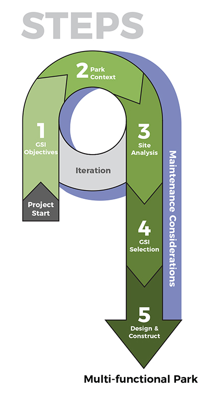
Recently we submitted questions to the design team. Enjoy a few questions below as we promote this important project and share some design inspiration!


Do you have a personal connection to the Bridge?

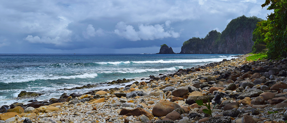
ELLEN – I bike, walk, or run past the bridge several times a week. I’m amazed at the changes in colors and feel that can happen from day to day on the rusted structure and the surrounding river. Even though it has had its fair share of abuse, the Seekonk River offers such a beautiful calm setting that it’s possible to forget you are in a city.

JON – Well I haven’t climbed it (yet), but for the last 15 years I have been part of a group of neighbors advocating for improvements to this stretch of the Seekonk River shoreline just north of the Crook Point Bridge. Access to the water is a huge resource to the people of Providence, and like many post-industrial cities, much of our coastline is hard to access and has crumbling infrastructure. We started advocating for green infrastructure and a watershed plan in 2007 and put a plan together for pedestrian/bike and shoreline resiliency improvements in 2016. We’ve been helping search for implementation funding since.


Did the design incorporate any elements of Rhode Island history/culture? If so, how?

ELLEN – There were elements discussed during the design phase that would help tie the structure and site into the history of the corridor as railroad tracks. This included train station seating and use of the railroad ties throughout the site. However, the structure itself and its location on the Seekonk River is the best connection to the past and depiction of change over time. We wanted to maintain the rusted look during the day to keep the ‘in ruins’ appearance against the river background to remain as a reminder of the changes we’ve made to the land. Incorporating the interactive/programmable lighting at night, connects us to the present with the opportunity to depict culturally relevant topics.

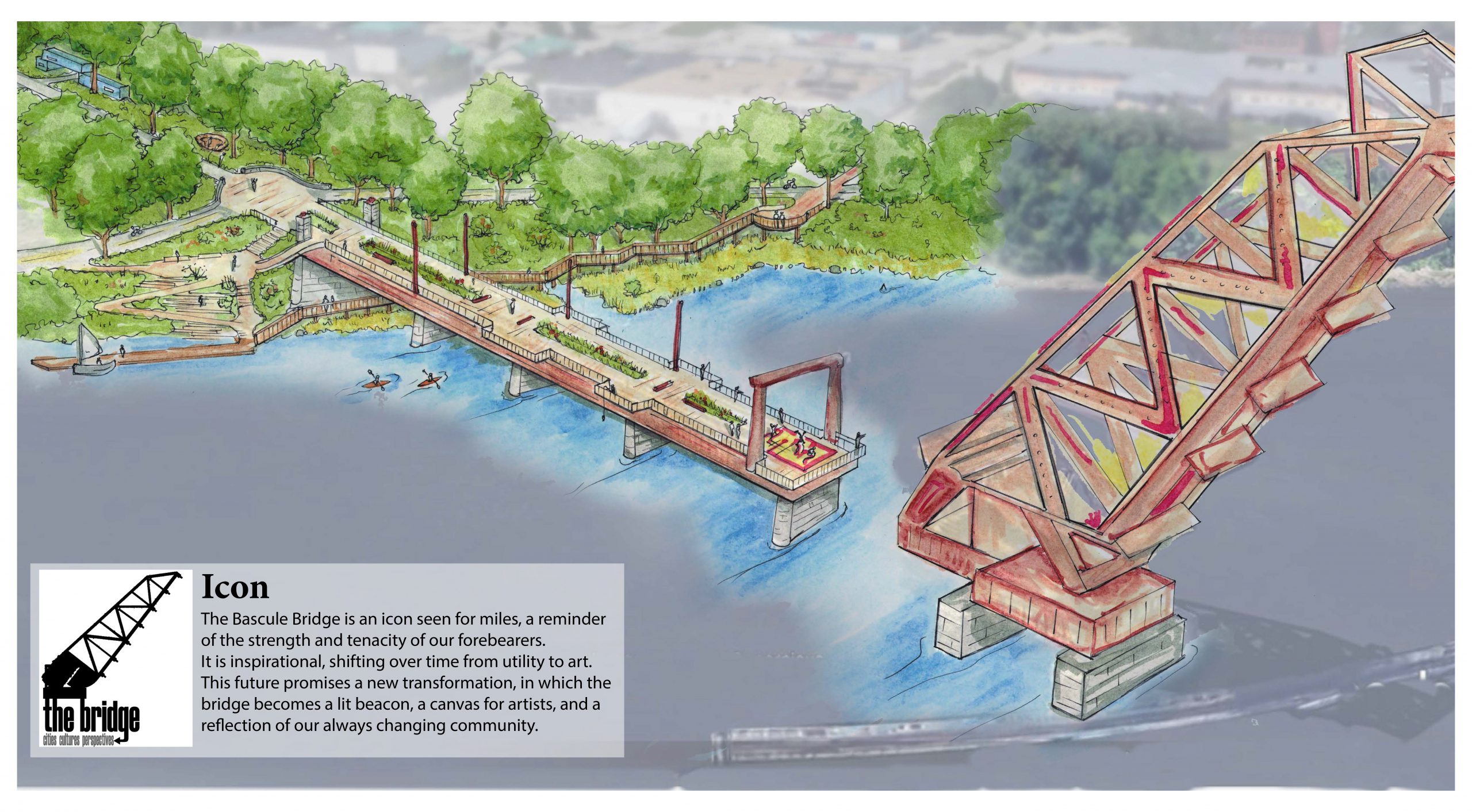
JON – On a personal note, the bridge is a strong symbol of Providence – history and culture. Physical elements of a neighborhood or city like this bridge provide people a connection to where they live that is hard to put your finger on but important in terms of their sense of belonging and pride. This bridge is like that for Providence, to the extent that it’s on t-shirts and it’s on postcards. Often when we work on neighborhood planning and urban design projects, we’re seeking to recreate these postcard moments, so when we already have them, we should celebrate them!


Love the idea of the lights illuminating the structure at night, did something inspire this concept?

JON – Living in the area we have a sense of how the bridge is a visual touch point – even without lights. You can see glimpses of it from so many locations on both sides of the river, in Providence and East Providence. You can see it from the highway and the Henderson Bridge. As part of our research, we did a photo study showing various perspectives and it was remarkable how visible it is. So, we thought that celebrating the bridge had to include creative and flexible lighting.


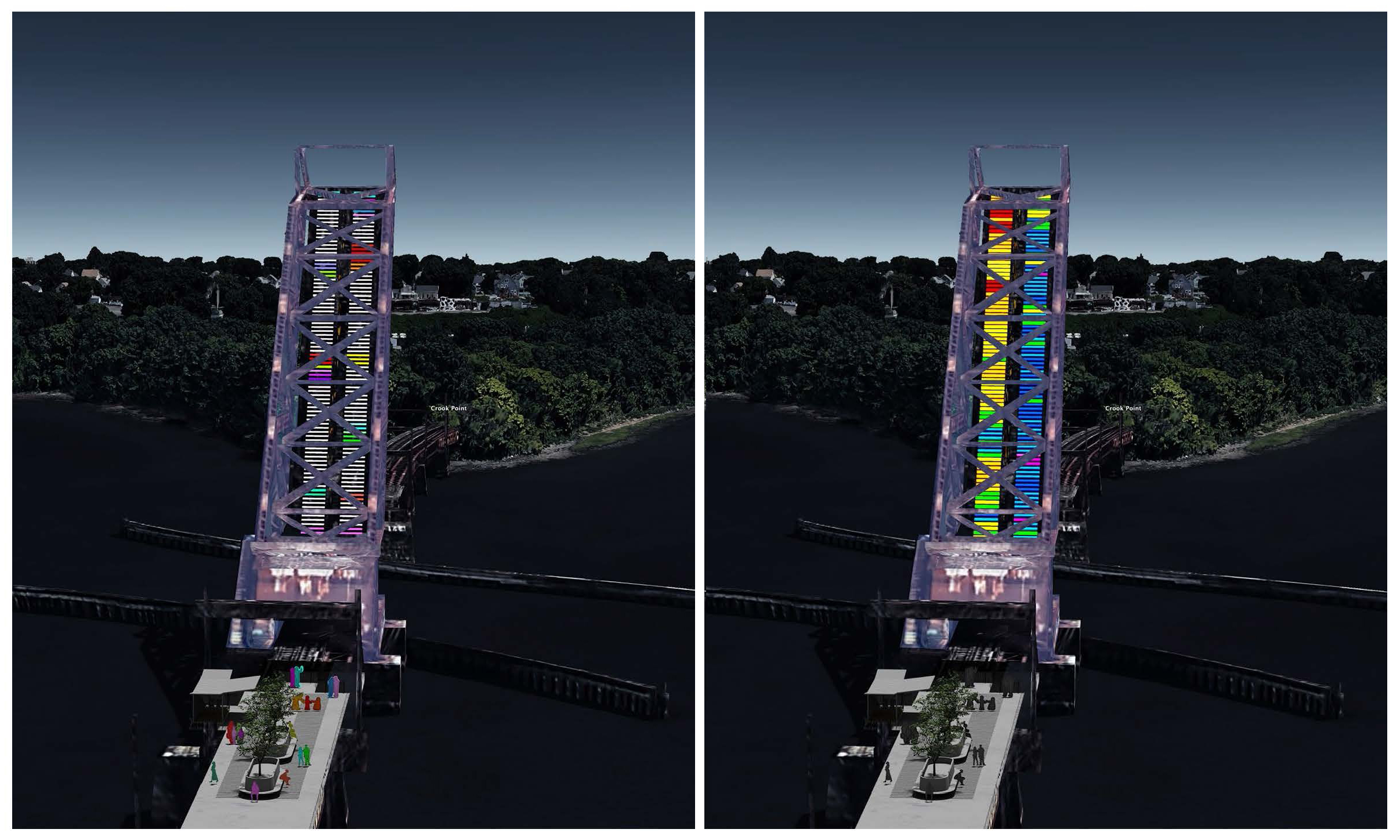
If the bridge structure is a beacon, what does it say?

JON – We thought it was critical, and honestly – obvious, that the bridge lighting design should be flexible and allow for various voices and perspectives to be expressed. We had some ideas – including interaction with the lighting system from the piers and the ability for the bridge to reflect nature such as tides or sea level rise. But it was most important to us to provide a canvas that could adapt. As a result, that will help show that the shoreline and this special place will be welcoming to all. We illustrated a few examples on the submittal, as there are so many possibilities!


The interactive LED’s that show motion below the bridge sound like a great idea. Are there any examples of existing structures with similar real-time sensors to give people an idea of what this may look like?

JON – I have always been inspired by the work of Herbert Dreisetl, a German landscape architect. His designs elevate to the level of art, and one I remember him presenting at a conference was a reflecting pool for a small German town square. The design uses microphones in the square that trigger vibrations in the pool based on ambient sound levels, and lighting is designed to project the ripples in the pool onto the buildings that enclose the square. So, the background lighting is more animated during the day, or when there are events, etc. – and calm when the square is calm. Also, visitors can interact with the space in a unique way. This bridge is obviously a bit different, but for me, the idea of finding different ways to project activity in a public space is linked to that.


What part of the proposed design are you most excited about?

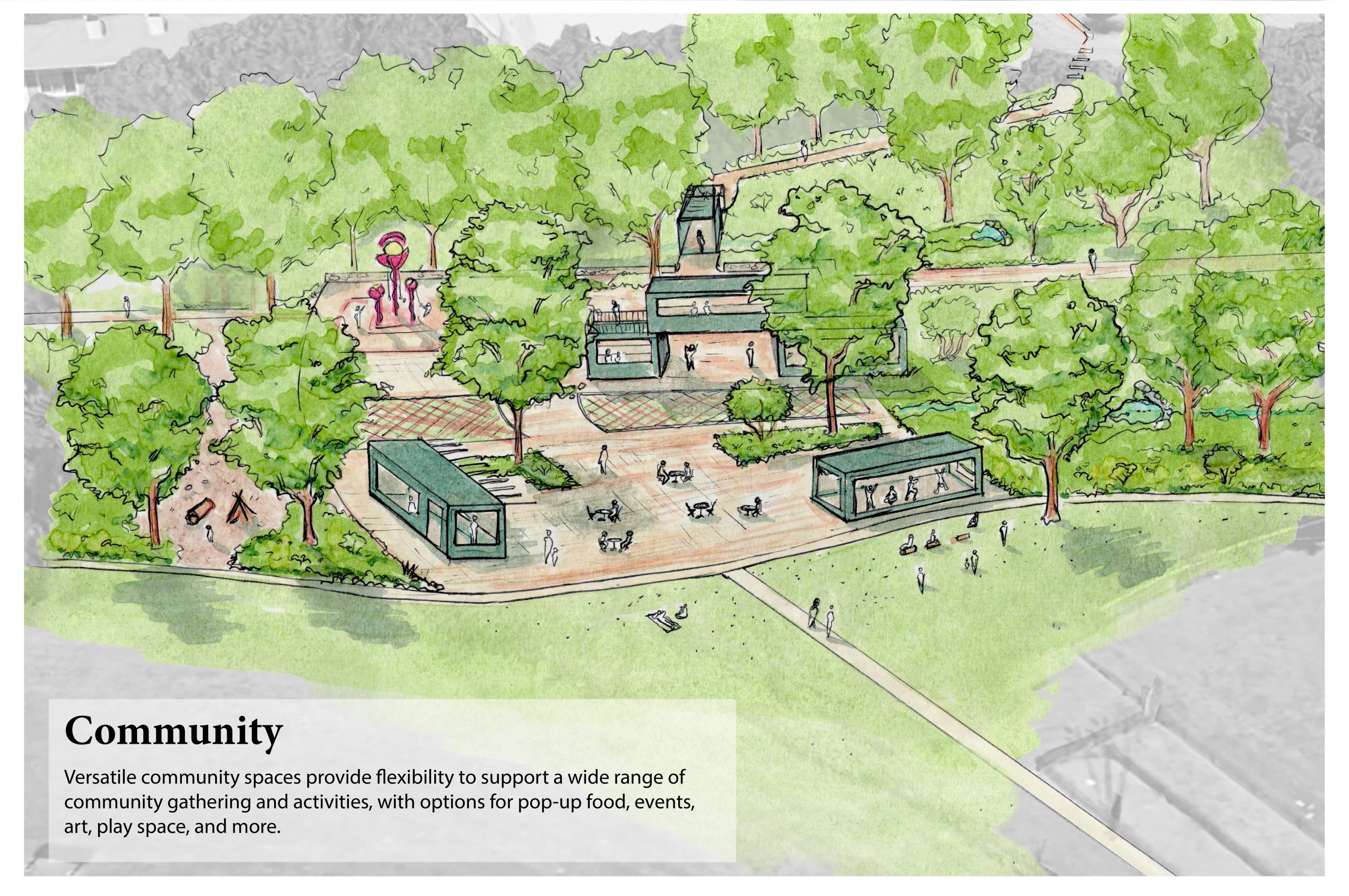
ELLEN – This is a hard question as I am excited about many parts of this design.  If I had to pick, I would  say the community element.  Community engagement and interaction are components we tried to weave throughout the entire design. Having spaces that encourage neighbors to engage through lights or other interactive art elements, can encourage community building and promote play for everyone – something we could all use. Also, this past year has proven how important it is to have flexible outdoor space for community gathering, mental health and is vital for a healthy city.

JON – That’s a good question. Once the project is built, I think what will be most exciting for me is to see people of various backgrounds, ages, life experiences, enjoying the shoreline in ways they never have been able to. If this is built as envisioned, it will mean a lot of different things to different people, and I look forward to seeing that result! I also can’t wait to bring my kids there and see them running up the pier to see the bridge up close. That will be truly amazing!


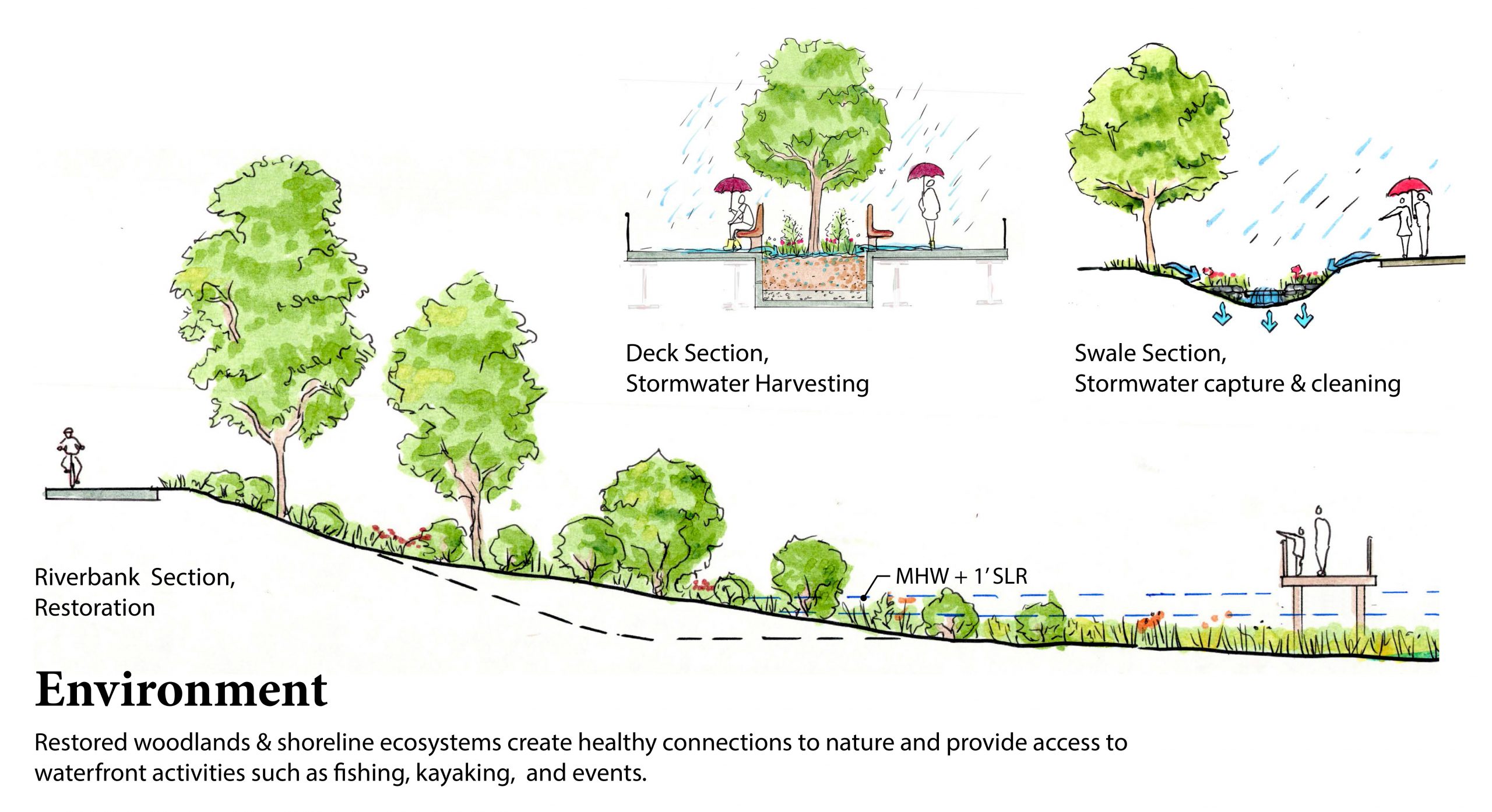
I see fishing and kayaking mentioned. Can you discuss the challenges of creating waterfront access for multiple uses and how this design addresses those challenges in creative ways?

ELLEN – Finding space for people to interact with the river while balancing restoration and multiple uses was approached by layering the benefits of each component. The accessible ramp that provides access for kayak users doubles as the path for seating, so the dock at the bottom could be utilized as a stage for small gatherings. The pier includes areas off the center walkway with space for someone to set up a fishing line and stay for a while without feeling like they are being crowded out. These little niches would include areas for fishing equipment and poles but when not in use, would appear to be an overlook and blend into the rest of the usable space.


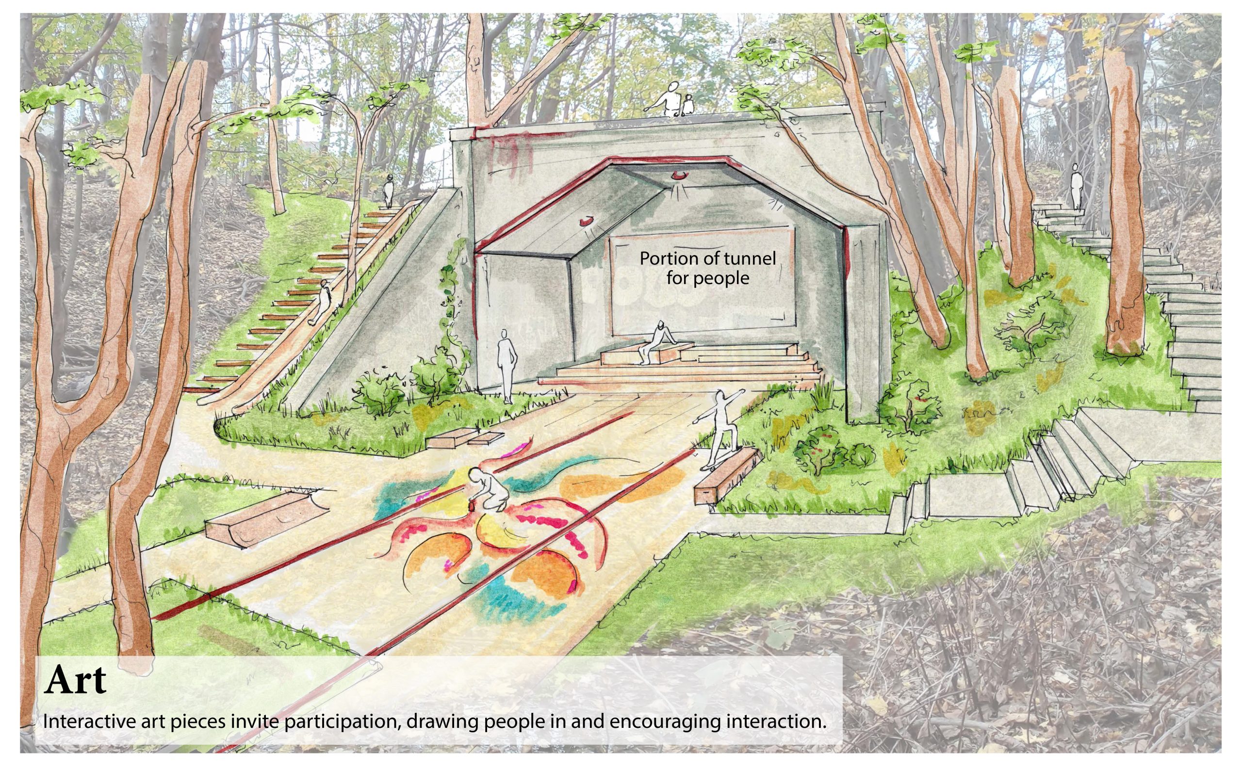
The design is super cool. I especially like the shout-out to bouldering as a potential use near the tunnel. Providence has one of the best bouldering sites in the area (Lincoln Woods) and there are at least 3 climbing gyms in the area, so this is a great opportunity to share the sport with folks who might not be able to access those other places to climb.  Are they proposing real boulders, or some artificial set-up?

ELLEN – Thanks! The back tunnel area has a lot of potential to become a unique feature and incorporating a use that people seek out is important for activating the space. Bouldering and climbing could fit this space well and having more locations in the city may help the community grow. As far as the specific material, there aren’t existing natural features, and the specifics for layout and material would be developed with the local community who would be using it, as well as balancing choices with other goals such as maintaining canopy and incorporating art elements.


Do you have any more details to share about the mixed-use housing (i.e., funding source, NGO; timeline, etc.)?

JON – We proposed the mixed-use housing as an aspirational idea for the City’s consideration. This idea will require more thought and discussion to become a reality! We included it because we think more activity will help bring more people to the shoreline 24-7, providing much-needed housing, helping to activate the public spaces, creating safety through having more “eyes on the street”, and helping generate tax revenue for the city. It will also make the public spaces livelier if they have commercial space woven in – like cafes, restaurants, and maybe even small-scale shops.


Who will be designing the art pieces that get installed? Will they be local?

JON – We think it should be a requirement that art pieces should be designed locally. There is great precedent for that with public art in the City via , Arts, Culture, and Tourism, the Avenue Project  and much more. That will be another element that defines the space that remains authentically Providence and welcoming to all. The process is to be determined, but it could also be evolving where pieces rotate in and out over time.


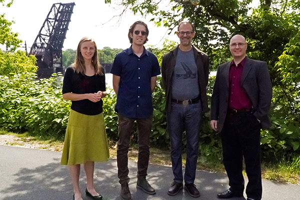
Ellen Biegert, Jon Ford, Jonathan Harris, Jason Rainone

green stormwater infrastructure

Boston Parks & Recreation Department


Introduction

HW and Brown Richardson and Rowe, have collaborated with the Boston Parks and Recreation Department (BPRD) on the creation of the Green Stormwater Infrastructure Design and Implementation Guide.

This  effort included invaluable contributions from the Boston Water and Sewer Commission (BWSC) and the Trust for Public Land (TPL). We thank BPRD staff for their time, resources, and dedication to this project. The Boston Society of Landscape Architects (BSLA) recognized this project with a Professional Merit Award in Communications in 2021.


GSI in Boston Parks

Considered the city’s first GSI project, Frederick Law Olmsted’s Emerald Necklace park system passes through many Boston neighborhoods. Olmsted’s brilliant stormwater management system has connected people to nature for over 100 years and serves as a prime example of the importance of incorporating GSI into parks and vice versa.

The types of properties managed by the BPRD are diverse and vary by scale, use, age, and surrounding contexts and communities. They also represent many things to those communities such as places to gather, play, exercise, recreate, and connect with nature. Such an assorted set of public spaces creates challenges as well as opportunities to create multi-functional parks.


5-Steps to a multi-functional park

Based upon information gathered from other municipal agencies throughout the country, the Guide uses a five-step process to assist BPRD staff, partnering city agencies, and park consultants, with the design, implementation, and maintenance of GSI. This will create more resilient, multi-functional parks that maximize benefits to park users and the environment.  

Key steps that help accomplish this goal include: defining and re-defining GSI objectives, identifying the park contexts, understanding the site and the benefits and maintenance requirements of various GSI practices, and leveraging partnerships.


Collaborative Process

We worked closely with BPRD staff, using information from BWSC and TPL, to prioritize GSI implementation in parks in every neighborhood.  GSI can help reach city-wide environmental and equity goals by improving climate resiliency and livability and health through promoting rainwater reuse and recharge, adapting to increased flooding, reducing urban heat islands, connecting people to nature, increasing green spaces, and improving drainage, water and air quality, and habitat value in parks all over Boston!


Click here for an example of a practice page outlining considerations for designing GSI in parks.


Journey to the south Pacific, American Samoa

Geoff Glover, P.E., Sr. Engineer

Geoff has over eight years of professional experience as a civil/environmental engineer specializing in stormwater management, site design, grading and drainage systems, and hydraulic/hydrologic modeling.


“American Samoa, and the entire Samoan Archipelago, is such a unique and enchanting yet fragile place in the world, environmental protection needs to be a priority here…”

Talofa! (hello)!
7,641 miles, 18 hours, and 5 inflight meals. Getting anywhere in the South Pacific takes a bit of planning, whilst traveling back in time and sleeping at a 60-degree angle for as long as you can. In this case, I am headed to the main island (Tutuila) of the United States’ southernmost inhabited territory of American Samoa, a 50-square mile rugged volcanic land mass located 18 degrees south of the equator. 

Project Goal
The goal was to to educate and inform contractors and local agencies about the impacts of soil erosion that occurs during land development and how to prevent sediment traveling from a construction site to the ocean.

American Samoan islands, like many islands in the Pacific, are mostly surrounded by fringing coral reefs that protect the shorelines from wave energy that is constantly stirring in the vast blue void covering 71 percent of the Earth’s surface. These reefs are vital for the longevity of coastal Samoan communities and their island history that has developed over the past millennia. Unfortunately, they are also extremely vulnerable to land-based sources of pollution like sediment from construction sites.

Arrival
Stepping out of the customs checkpoint at Pago Pago International Airport, I could immediately tell we weren’t in Kansas (Cape Cod) anymore. First of all, we were outdoors and immediately sweating and secondly, there seemed to be a large welcoming committee for the incoming travelers. With the only flights to and from the US on Monday and Thursday evenings, and the long distance from the mainland, the airport becomes a great place for impromptu reunion or farewell parties for many locals. But there we were, four pālagis (pronounced pah-lon-gee – native word for foreigner) navigating their way through the many Samoan families. Despite having just endured the experience of traveling halfway across the world with my head full of new information, there was still room for a couple of Vailimas (a local beer) before turning in for the first night.

Let’s Get to Work!

Over the next four days, we immersed ourselves in island culture and traditions, identifying locations of active construction sites scattered about the island, and engaging in MANY conversations – the main topic – soil erosion and the importance of sediment control.

We presented to a group of 20 local contractors from several different construction companies on island. While they were extremely knowledgeable about construction techniques on their island, engineering & problem solving, and typical sequencing of day-to-day construction activities – there was a lack of awareness of how best to both minimize erosion and control the amount of sediment leaving a site. Which is why we were there. Our expertise is in protecting fragile environments from the impacts of human activities on land, and we have been training contractors and inspectors about these important issues throughout the Pacific for over 10 years!

What’s Wrong With a Little Dirt?

During construction when natural vegetation is removed and the ground is disturbed, the newly exposed soil becomes highly susceptible to erosive forces when it rains. There are several factors on tropical islands that heighten this effect – total amount of rain (e.g., over 200 inches per year in parts of Tutuila!), rainfall intensity and frequency, mountainous terrain, and fine-grained soils. These factors can result in extreme amounts of sediment-laden runoff that can suffocate the downstream aquatic environment, in particular, coral reef ecosystems. The on-the-ground construction workers are often the last line of defense! Properly installed and maintained erosion and sediment controls can help reduce the amount of sediment leaving the site and protect this delicate environment. 

My Takeaway

American Samoa, and the entire Samoan Archipelago, is such a unique and enchanting yet fragile place in the world. Environmental protection needs to continue to be a priority here, including erosion and sediment control for construction sites. This was an extremely rewarding experience as we were able to transfer this idea and knowledge with the locals. On our final day, we received parting gifts from our trainees along with countless “Fa’afetai tele lava (thank you very much)” – truly a special moment. All the travel, long workdays, jet lagged mornings, loss of fluids (sweat, so much sweat…), and little bedroom critters were worth the opportunity to inspire a new fleet of “sediment warriors” on American Samoa!